Special Marine Areas in Newfoundland and Labrador
The ocean surrounding Newfoundland and Labrador is rich in marine ecosystems that support marine life from the largest whales to the tiniest plankton, upon which generations of people and a cherished way of life has depended on. Our province boasts the Grand Banks, with some of the most important and productive marine ecosystem in the world. We are also known as the ‘Seabird Crossroads of the World’, hosting millions of migratory seabirds every year. We also have a burgeoning eco-tourism industry, centered partly around whale and bird watching experiences. Newfoundland and Labrador has a real chance to be ocean conservation leaders.
However, the continued declines in ocean health, including local fish populations, demonstrate that existing conservation measures are not enough to ensure the long-term survival of species and ecosystems upon which our coastal communities depend, especially in the face of a variety of human activities.
Click the button below to view the Special Marine Areas in Newfoundland and Labrador Guide, 2nd Edition, where with the help of scientists, governments, ENGOs, and community groups, have highlighted 140 special marine areas that include coastal sites, coral beds, bird colonies, fish spawning grounds, and migratory routes.
Bonavista Bay

Bonavista Bay is a large exposed bay on the North Atlantic coast of Newfoundland. Due to the cold Labrador Current, icebergs are common in the summer. Bonavista Bay is within the Newfoundland Shelf region of Parks Canada’s National Marine Conservation Areas system.
Special Features
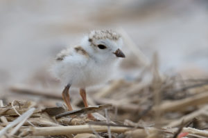
The coast around Bonavista Bay is irregular, comprising narrow bays, sounds, inlets, coves and islands, which provide ideal nesting locations for a number of birds. The area is highly productive due to the cold Labrador Current. Subtidal fauna, seabirds and marine mammals in Bonavista Bay are diverse and abundant. Bonavista Bay provides habitat for many species, and contains many spawning sites for cod, herring, capelin, and lumpfish. There are several seabird breeding colonies within the ecoregion, including Leach’s Storm-Petrel, Common and Arctic Terns, Black-legged kittiwake, Atlantic Puffin, and great Black-backed, Herring and Ring-billed gulls. Common Eiders nest in some parts of the ecoregion; however, their numbers were severely reduced due to hunting around the turn of the century, and are only now increasing slowly. Lumpfish (Cyclopterus lumpus)
Within Bonavista Bay is Alexander Bay, which has been called the most ecologically unusual marine area in Terra Nova National Park due to unusually high water temperatures which provide habitat for species not normally found in Newfoundland and Labrador. For example, it contains seaweeds and invertebrates which, with the exception of Prince Edward Island, are normally only found South of Cape Cod. Parks Canada has identified the area from Cape Bonavista to North Head (Notre Dame Bay), and offshore to Funk Island as an Area of Interest, a preferred site for consideration as a possible National Marine Conservation Area in the Newfoundland Shelf region.
Protection
Terra Nova National Park makes up part of the terrestrial and coastal area of Bonavista Bay, but offers limited marine protection, and major capelin spawning beaches are outside the park boundary. There is a 2.1 km² Marine Protected Area (MPA) within Eastport which was created form the community up to protect their lobster stocks. Newman Sound is a Migratory Bird Sanctuary aimed at conserving migratory bird diversity by controlling human activities within important areas.
Hamilton Inlet

The coastal area around Hamilton Inlet falls within the Coastal Barrens and Mid Boreal Forest ecoregions. The entire inlet falls within the Labrador Shelf region of Parks Canada’s National Marine Conservation Areas system. Important areas within Hamilton Inlet include the Gannet Islands, Groswater, Table Bay and Sandwich Bay. Four major rivers drain into Hamilton Inlet: Churchill (Mishta-shipu, grand), North West (Naskaupi), Kenamu, and Goose, draining a significant portion of the Ungava Peninsula.
Special Features
Hamilton Inlet and Lake Melville form the largest estuary in Labrador, and contain significant waterfowl, seabird, and other migratory bird colonies and habitats. Some of the largest aggregations of staging waterfowl in the province occur here in Spring and Fall. Hamilton Inlet is also part of the historical range of the endangered Eskimo Curlew, which may now be extinct. Some waterfowl species of special conservation concern breed in the area, including Black duck, Surf Scoter and Black Scoter.
These species are the focus of the Black Duck and Sea Duck Joint Ventures under the North American Waterfowl Management Plan. Lesser Scaup and Harlequin Duck, which breed in a number of locations in the Mealy Mountain National Park area, are receiving increasing special conservation attention due to continental-level population declines. Intertidal marshes in the area contain unique flora, including temperate and arctic species, as well as species that occur on both sides of the Atlantic. Saltmarsh Cordgrass, which plays an important role in stabilizing shorelines, is rare in Newfoundland and Labrador and this area is its northern limit. The Gannet Islands are an Important Bird Area and contain the largest and most diverse seabird breeding colony in Labrador, with tens of thousands of pairs of Atlantic Puffins, Common Murres and Razorbills. They contain the largest Razorbill colony in North America, and the second largest breeding colony of Atlantic Puffin in eastern North America. They are also the largest known moulting site for Harlequin Duck in eastern North America, with approximately 300 individuals moulting annually. Seals also whelp on the islands, coasts and pack ice in the area, or migrate through.
Protection
Hamilton Inlet has been identified by Parks Canada for consideration as a National Marine Conservation Area. The area is within a Fisheries Conservation Closed Area related to salmon fishing and conservation. The estuary of the Eagle River, which flows into Sandwich Bay, is also a Fisheries Conservation Closed Area. The Gannet Islands archipelago is a Seabird Ecological Reserve protecting Common Eider, Razorbills, Common Murre and Atlantic Puffin and their habitats, and the use of motorized vehicles or equipment within the reserve is prohibited.
Torngat Mountains Marine Area

The Torngat Mountains are the highest mountains in Canada east of the Rockies. The area has been the home of Inuit people and their predecessors for millennia, and contains a National Park that extends from Saglek Fjord to the northern tip of Labrador, and to the with Québec border. The Torngat Mountains are within the Alpine Tundra ecoregion, and their coast falls within the Labrador Shelf region of Parks Canada’s National Marine Conservation Areas system. The coast in the Torngat Mountains region consists of cliffs up to 900 m in height, bays and fjords that extend into the mountain ranges, and a number of offshore islands. Marine sediment deposits extend many kilometres inland from the heads of the fjords.
Special Features
Seven Islands Bay and Galvano Island, located in the marine area adjacent to the Torngat mountains, have been identified as Important Bird Areas (IBAs). Both are significant for congregating bird species, and threatened species. Some 22% of the estimated eastern North American population of the Harlequin duck was observed in Seven Islands Bay in July 1994. This is the largest concentration in Labrador of Harlequin duck, which is a COSEWIC-listed Species of Special Concern. Galvano Island is significant for large numbers of breeding Common Eider, subspecies borealis.
Photo By: Jeannine Winkle
Protection
The area is within a Fisheries Conservation Closed Area related to salmon fishing and conservation. The Torngat Mountains received full National Park status in July 2008, but it has no marine component. Traditional fishing and hunting activities are allowed within park boundaries; however, the area is free from commercial and industrial development.
Threats
Although the area is used by Inuit for hunting, fishing and traveling, it remains pristine. Oil spills from shipping traffic could threaten the birds at Seven Islands Bay and Galvano Island. The area is also threatened by potential oil exploration and development on the Labrador Shelf.
Nain Coastline and Offshore Areas

The Nain coastline is an area bounded by Humbys Island, Dog Island, and the western and northern coasts of Paul Island. This complex coastline is made up of hundreds of islands, islets and shoals with rocky shores. Circulation in the area is dominated by the cold Labrador Current. The Nain area falls within the Coastal Barrens ecoregion, as well as the Labrador Shelf region of Parks Canada’s National Marine Conservation Areas (NMCAs) system. The land in the area is owned by the Labrador Inuit and governed by the Nunatsiavut Government. There are two main rivers and many small streams that empty into the area, leading to extensive delta-related deposits and boulder-strewn intertidal flats. Dunes vegetated by stabilizing grasses, raised beaches, and salt marshes are also present along the coastline.
Special Features
Nain Bank is high in nutrients and primary productivity, due to local upwelling and transport of nutrients from the Hudson Strait, resulting in rich and diverse biota in the area. In Nain Bay, Pacific, Arctic and European fauna mix, resulting in high diversity among sublittoral benthic macrofauna. Portions of the coastline southeast of Nain and the offshore islands in the area have been identified as IBAs. The offshore islands support large numbers of nesting seabirds and are considered globally significant for congregating species and colonial seabirds. Species present in significant numbers include over 3% of the estimated North American population of Atlantic Puffin, 2.2% of the estimated North American population of Razorbill and 1.4% of the estimated North American population of
Photo: Yann Rouxel
Glaucous Gull. Thick-billed and Common Murres, Black Guillemot, Great Black-backed and Herring Gulls also nest in large numbers. The islands also have significant concentrations of fish, seals and whales, are rich in artifacts and provide important marine resources to local people. The Nain coastline, including the offshore islands in the area, supports large numbers of moulting scoters. Between 16,000 and 19,370 scoters were recorded in 1998-1999, including 12,500 Surf Scoters, representing at least 1% of its estimated global population. Harlequin Ducks have been observed on the Nain coastline, and Peregrine Falcons nest in the area. Common Eiders also nest on several islands in the area.
Protection
Nain Bight, as a representative area of the Nain Bank, has been identified as a possible NMCA (along with Hamilton Inlet/Hamilton Bank). The Nunatsiavut Government has yet to designate any special marine areas within a Fisheries Conservation Closed Area related to salmon fishing and conservation.
Threats
Contaminants and oil pollution can be trapped behind the islands and in the bays around Nain, and intertidal flats and beaches may retain contaminants. The shipping route associated with the Voisey’s Bay mine is a potential threat to the birds. The presence of many shoals and small islands in the area increase the threat of oil spills.
Fogo Shelf

This Area Includes Bay of Exploits, Inner Shelf Area, Twillingate Island, New World Island, Fogo Island, and Cape Freels. It falls within the Eastern Hyper-Oceanic Barrens ecoregion, and is also located in the Newfoundland Shelf region of Parks Canada’s National Marine Conservation Areas system. Little Fogo Islands is an archipelago with over 100 small islands directly north of Fogo Island.
Special Features
The cold, productive waters of the Labrador Current and upwellings on the Funk Island Banks lead to an abundance of zooplankton and breeding fish around the island, supporting a diversity of groundfish, pelagic fish, shellfish, marine mammals, and aquatic plants. The area is considered ecologically significant for several marine species such as lobster, capelin and herring. It is known to be important for juvenile fish. The many islands in the area provide habitat for marine waterfowl such as eider ducks, black ducks, terns, and cormorants. There are several seabird breeding colonies within the ecoregion, including Leach’s Storm-Petrel, Common and Arctic Terns, Black-legged kittiwake, Atlantic Puffin, and great Black-backed, Herring and Ring-billed gulls. Common Eiders nest in some parts of the ecoregion, but their numbers were severely reduced by hunting which occurred at the turn of the century; their numbers are now slowly increasing. In 1997, local fishers, developers and conservationists proposed the establishment of an MPA in Fogo Shelf, including three IBAs, as a response to the decline in marketable species, the cod fishing moratorium and increased fishing pressure on lobster in the area. Studies have
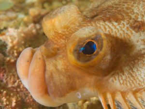
Photo: Ken Reid
highlighted the cooperative and conflict-free nature of this initiative as a strong example of integrated management. This area has been identified as an area of interest for the establishment of an MPA, with the inshore region of the northeast Newfoundland shelf, from White Bay to western Bonavista Bay. The purpose of this MPA would be to conserve and protect local lobster stock and their habitat, local capelin beaches, important Atlantic Cod nursery areas, and important areas for Winter Flounder.
Protection
This area Contains an Ecological Reserve Community-based ocean conservation and research project among communities of Fogo Island, Change Islands, Leading Tickles, Carmanville, Funk Island and Little Fogo island. Funk Island is a provincial Seabird Ecological Reserve and International Biological Program Special Site, aimed at protecting Northern gannets and Common Murres. Funk Island is closed to hunting, and access to the island is restricted. Following a proposal submitted by the local community, work has begun towards the designation of this area as an MPA.
Threats
The seabirds in this area are vulnerable to the effects of human disturbance, toxic pollutants, oil pollution and fisheries – including entanglement in gear and competition for food. Illegal visits to the island are still common, despite prohibition of unauthorized human activity. The Common Murre colony is particularly sensitive to disturbance during the breeding season. Human impacts and possible threats to the area include effluent or contaminant spills from coastal communities, effluent from sawmills, and sewage outfalls. There has also been a noticeable increase in water temperature on the northeast coast of Newfoundland since the mid 1990s.
Witless Bay

Witless Bay is located off the east coast of the Avalon Peninsula of Newfoundland, between Bay Bulls and Mobile. Witless Bay is comprised of four islands: Gull, Green, Great, and Pee Pee Islands Seabird Ecological Reserve. Witless Bay is within the Southeastern Barrens subregion of the Maritime Barrens ecoregion.
Special Features
Witless Bay has been designated an IBA, due to its globally significant seabird breeding colonies. Species at risk inhabit the islands that make up the Reserve. More than one million pairs of seabirds of 10 different species breed on the Witless Bay Islands. The Witless Bay Ecological Reserve contains the largest Atlantic Puffin colony in North America with approximately 300,000 pairs estimated to nest there. The Reserve houses one of the largest Leach’s Storm-petrel colonies in the world, with approximately 315,000 breeding pairs. It also has the largest colony of Blacklegged Kittiwakes in Newfoundland and Labrador with 40,000 pairs, making up approximately 50% of the breeding population of kittiwakes in Newfoundland and Labrador and 16-22% of the western Atlantic breeding population. It has the 2nd largest colony of Common Murres in eastern North America with 77,000 pairs, signifying 2% of the Atlantic and 13% of the eastern North American breeding populations. The Witless Bay islands contain breeding populations of Razorbills, Black Guillemots and the first known Northern Fulmars to breed in Newfoundland. Gull and Great Islands were found to house over 4300 breeding pairs of Herring Gulls and over 100 pairs of Great Black-backed Gulls in 2000. Common and King Eiders, Thick-billed Murres and Dovekies winter in the waters surrounding the Witless Bay islands, and the area is important for migrating sea ducks. Capelin spawn in Witless Bay, for example at Gull Island, and migrating populations of whales also go through the area. Gull Island and the other Witless Bay islands are within the Eastern Avalon Ecologically and Biologically Significant Area identified by Fisheries and Oceans Canada.
Protection
Photo: Greg Noel
The Witless Bay Islands have been designated a Seabird Ecological Reserve. The Ecological Reserve was established to preserve internationally important seabird breeding and overwintering colonies, maintain the natural communities of the Reserve, foster scientific studies, and provide the public with observation and educational opportunities. CPAWS-NL also conducts the Puffin and Petrel Patrol program during fledging season, and uses this opportunity to not only rescue stranded pufflings and petrels, but to raise awareness of light pollution and its effects on nocturnal seabirds. For more information click here: Puffin and Petrel Patrol
Threats and Recommendations
There is increasing concern about the levels of ecotourism in the Witless Bay area, particularly the impact of tour boat activities. Close approaches by boats, and tour boat operators aren’t subject to distance restrictions when approaching the islands. Close approaches to whales can result in behavioural reactions. The waters off the east coast of the Avalon Peninsula are also within a major shipping route, resulting in a threat of oil pollution.
Placentia Bay Extension EBSA / Cape St. Mary’s

Placentia Bay Extension includes all of Placentia Bay in Newfoundland, and the area from Point Crewe on the Burin Peninsula across the bay to Point Lance on the Avalon Peninsula. It falls within the Eastern Hyper-Oceanic Barrens ecoregion, and the grand Banks region of Parks Canada’s National Marine Conservation Areas system.
Special Features
Placentia Bay Extension is within the top three priority Ecologically and Biologically Significant Areas (EBSAs) identified for conservation in the Placentia Baygrand Banks Large Ocean Management Area (LOMA), and has also been identified as a Coastal Management Area. The Placentia Bay-grand Banks LOMA is recognized by Fisheries and Oceans Canada as one of five priority LOMAs in Canada. High primary and secondary production occurs in Placentia Bay and its headlands. Placentia Bay contains standing and bay stocks of certain fish species concentrations of ichthyoplankton of fish such as cod,
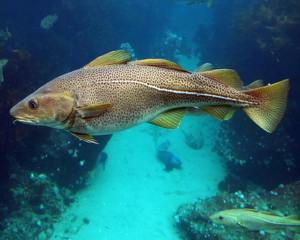
Photo: Northeast Fisheries Science Sector
cunner, plaice and capelin, as well as spawning and nursery habitat for these same species. It contains the largest spawning stock of Atlantic Cod in the northwest Atlantic Ocean. There is high pelagic and demersal diversity in the bay and its extension is a vital Bird Area due to the presence of nesting, feeding, aggregation, refuge and overwintering sites of many bird species, including seabirds such as Atlantic Puffin, Black-legged kittiwake, Black guillemot, Common Murre, great Black-backed gull, greater Shearwater, Northern Fulmar and Northern gannet. Harbour Seals, otters and some cetaceans use the area throughout the year, and Leatherback Turtle and migratory cetaceans aggregate and feed in the region in spring and summer. The area is particularly important for Harbour Porpoise and Humpback Whale feeding, due to prey concentrations. Harbour Seals pup in three sites, and otters reproduce in the area. Female cetaceans with young are found in the bay during critical feeding times.
Protection
Placentia Bay is a fisheries management area established to protect scallop stocks from commercial harvesting, and Point Verde to Red Harbour Head is closed to recreational scallop fisheries. Cape St. Mary’s is a Seabird Ecological Reserve, and Come by Chance is a Wetland Stewardship Area that protects waterfowl staging habitat.
Threats
Murre and Razorbill breeding populations have been depleted, and Harlequin ducks decreased to three dozen in the mid-1990s. Threats to the ecosystem include marine pollution, over-fishing and scallop dragging activities, depleted food stocks, and accumulation of toxic chemicals. High levels of commercial and industrial activity in and around Placentia Bay have led to contamination and disturbance in a number of regions.
Hermitage Bay

Hermitage Bay is a small coastal bay on the South Coast of Newfoundland. The climate in the area is mild in the winter and cool in the summer. The bay falls within the South Coast Barrens subregion of the Maritime Barrens ecoregion. It is located in the Laurentian Channel region of Parks Canada’s National Marine Conservation Areas system.
Special Features
The area is rich in marine biodiversity. Deep water fauna exists just offshore of Hermitage Bay, and in Bay d’Espoir, an unusual phenomenon in waters so close to shore, and both Conne and Little River are historically important area for Atlantic Salmon. There has also historically been an abundance of fish at Fox Islands in Hermitage Bay. The ecoregion contains some seabird nesting areas, as well as
Photo: DFO
greenwinged Teal and Least Sandpiper breeding areas. Archaeological evidence exists of Maritime Archaic Indians, Paleo-Eskimo, dorset Eskimo and Beothuk presence on Long Island at the entrance to Hermitage Bay.
Protection
The area is within Fisheries Conservation Closed Area, aimed at protecting populations of spawning redfish. It is also within Fortune Bay Fisheries Management Closed Areas, initiated by inshore fishers, that are closed to most otter trawling.
Threats
Hermitage Bay is on a ferry route, therefore there is a threat of oil pollution. Bay d’Espoir has been used as a dumping ground for old ships – two old sidetrawlers from the gaultois fish plant were scuttled there, without being decontaminated in advance.
Gros Morne Marine Area

Gros Morne National Park is a worldheritage site located on the west coast of Newfoundland, characterized by coastal plains, fjords and coastal cliffs. The topography of the bay is complex, with irregularities due to estuaries, sedimentary bars, mountainside slumping, hard bedrock outcrops, boulder fields and rock slides. The Bonne Bay Marine Station located in the park specializes in marine research and education.
Special Features
This area was recognized as a UNESCO World Heritage Site in 1987 due to its unique, accessible, pristine geological features, and Tablelands geological site. The marine environment of Gros Morne is considered important by biologists for its variety of habitats and for having the highest biodiversity in Newfoundland. The stratification of seawater, and the convergence of the northern limits of boreal and temperate species and the southern limits of Arctic species result in high species diversity. Bonne Bay contains the highest biodiversity of seaweeds and kelp in Eastern Canada. Trout and char spawn in small creeks which run from ponds and lakes to the ocean. Lumpfish, herring and many other species also spawn in Bonne Bay. Canada goose nests in the coastal bog ponds of the subregion, and the at-risk Harlequin duck breeds in low numbers in the upper reaches of fast-flowing rivers. St. Paul’s inlet has an extensive salt marsh with a distinct mix of temperate and arctic species. Unique coastal habitats like sand shallows form here. The islands in the bay contain important shorebird nesting sites.
Photo: Great Big Canvas
Protection
Gros Morne National Park has been designated as a UNESCO World Heritage Site, but lacks any marine protection below the high water mark. Both St. Paul`s Inlet and Bonne Bay are surrounded by Gros Morne National Park, which protects a portion of the Western Newfoundland Highlands natural region.
Threats
Despite the species diversity in the area, over-fishing has caused population depletion. Major expansion of residential and tourism-related industrial development is occurring on portions of the shoreline that are not included in Gros Morne National Park. Other threats to the area include sewage outflow, terrestrial runoff, waste from local fish plants, and damage to intertidal zones.
St. George’s Bay, Port au Port

Special Features
St. George’s Bay contains many eelgrass beds and salt marshes. The Spartina salt marsh on the Port au Port peninsula and Sandy Point provides important habitat for birds and other animals. It houses rare plant species such as Seabeach Sedge, Saltmarsh Rush, Seaside Lavender, and Saltwater Cordgrass, amphipods, and fish also exist in the area. St. George’s Bay contains submarine fans that have not been seen anywhere else in the region. Herring also spawn in the area. Shorebirds and songbirds use the habitat in the area during fall migration and nesting season. Migratory shorebirds congregate in large numbers on tidal flats in the fall. Piping Plovers nest in the area. The only known nesting location in the province for Willet is on Flat Island in St. George’s Bay. Other nesting shorebirds in the area include Greater Yellowlegs, Common Snipe and Spotted Sandpiper. Flat Island contains colonies of Common and Arctic Terns, Ring-billed Gulls and Greater Black-backed Gulls. White-winged Scoters are sometimes abundant in nearshore areas. The area is also along an annual seal migration route.
Protection
St. George’s Bay and Port au Port Bay are Fisheries Conservation Closed Areas, aimed at conservation of Atlantic Salmon, Atlantic Herring spring spawning, and lobster. The bay is seasonally closed to scallop fishing, and a portion is closed to commercial scallop fishing.
Threats
Overfishing is an issue in the area, especially during herring spawning. Sandy Point is heavily impacted by all-terrain vehicle and horse travel. Several industrial threats exist to the area; for example, pulp and paper effluent has been found to affect Winter Flounder in St. George’s Bay. Mining activities also occur
South Coast Fjords
Newfoundland and Labrador is known for its exquisite natural beauty and productive coastal waters, and the South Coast Fjords are a perfect example of such. The area is a haven for species like blue, humpback, fin and killer whales in the winter and leatherback sea turtles in the summer. The establishment of the South Coast Fjords NMCA will preserve endangered species and ecosystems – both of which are important criteria for Canada’s network of marine protected areas.
Many marine mammals and rare species follow this route to feed in the sheltered bays, including leatherback turtles, harbour porpoises, and humpback, fin, blue, right, and killer whales. Endangered porbeagle sharks are also known to aggregate off Pass Island. The Burgeo Sandbanks contain extensive beaches and marshes which provide habitat for the globally-vulnerable Piping Plover.
You can learn more about the South Coast Fjords here!