Southern and Eastern Avalon Conservation Planning Initiative
Marine Conservation Planning in Newfoundland and Labrador
The Government of Canada has made a commitment to protect 30 percent of land and water by 2030, as well as halt and reverse nature loss in Canada by 2030 and achieve a full recovery for nature by 2050. The coastal and marine area surrounding the Southern and Eastern Avalon has the potential to contribute to these targets due to its ecological, cultural, and economic significance. A marine National Wildlife Area (mNWA) is being considered as a potential strategy among many other (spatial and nonspatial) strategies in a broader marine conservation planning initiative. This initiative is led by the Environment and Climate Change Canada’s Canadian Wildlife Service, partnering with the Canadian Parks and Wilderness Society – Newfoundland and Labrador Chapter (CPAWS-NL), Miawpukek First Nation (MFN), Fisheries and Oceans Canada (DFO), and the Government of Newfoundland and Labrador (GovNL). These partners, along with other interested parties from industry, academia, ENGOs, to locals, form a planning team. Together, the planning team is leading a joint effort to adopt an adaptive management strategy using the Conservation Standards Framework. This adaptive-management approach allows the process to be adjusted and refined at any time, as new information and perspectives are discovered. The initiative aims to maximize ecosystem benefits, while promoting the importance and sustainability of the coastal and marine environment to local livelihoods through effective conservation strategies.
Ongoing community engagement is underway to provide opportunities for local perspectives and knowledge to be incorporated into the process. The intent of this initiative is to support, sustain, and maintain access to our culture and livelihoods through effective conservation strategies. The potential implementation of this protected area will not impact current migratory waterfowl or murre hunting, nor will it affect existing regulations. Furthermore, ensuring the access to and sustainability of small-scale fisheries is a key priority of this effort.
The Open Standards for the Practice of Conservation
The Open Standards for the Practice of Conservation, or Conservation Standards (CS) for short, are a widely adopted set of principles and practices that bring together common concepts, approaches, and terminology for conservation project design, management, and monitoring. Developed by the Conservation Measures Partnership (CMP) and regularly updated in collaboration with the broader community, this open-source, strategic process helps conservation teams achieve lasting impact.

Where Are We Now?
Since June 2022, the planning team has participated in ongoing bi-monthly virtual workshops. Currently, the planning team are concluding Step 1 (Assess) of the Conservation Standards Framework. This step has involved defining the purpose and study area of the project, and identified biodiversity targets which we hope to conserve. Important characteristics that define the health of each target, or key ecological attributes (KEAs), were assessed to better understand their health. An extensive pressure assessment was also completed to determine the pressures impacting the health of each biodiversity target. The current workshops are focused on refining this assessment in preparation for developing situation analyses, which will help determine where these pressures are coming from. By using adaptive management, we can return, reflect, and adjust these metrics at any point in the process.
Who Is Involved
The planning team is made up of a broad representation from Federal, Provincial, and Indigenous Governments, non-profit organizations, and other interested parties. Information derived by the planning team is consistently verified with subject-area experts and current research. Incorporating local knowledge and perspectives is a crucial aspect of the project considering the coastal and marine environment provides a wealth of ecosystem services that support local livelihoods. Environment and Climate Change Canada’s Canadian Wildlife Service and CPAWS-NL are hosting engagement sessions to provide opportunities for locals to become involved, to develop a shared understanding of this project, and ensure their voices and perspectives are incorporated.
Project Scope
The project scope refers to the study area, which encompasses the area being considered for multiple conservation strategies, extending from Cape St. Francis to Placentia Bay. The study area extends 60 km seaward, with Cape St. Mary’s and Witless Bay Ecological Reserves as the centroid, connecting 40 km south of Cape Race. This seaward extension promotes an ecosystem-based approach to conservation planning, highlighting the ecological, cultural, and economic importance of the area. Using this approach, it is possible to gain a holistic understanding of the area’s importance, creating a plan to conserve for the next seven generations. Key features captured in the study area include fish spawning and nursery grounds, foraging areas, and migration corridors for several marine species.
Sites
The Government of Canada’s February 2023 announcement on the Pathway to 2025 includes consideration of Witless Bay and Cape St. Mary’s for conservation. The study area is a seaward extension of both locations to include the ecologically and biologically significant marine areas of Southern and Eastern Avalon, promoting an ecosystem-based approach to conservation planning.

Southern Avalon
Newfoundland and Labrador
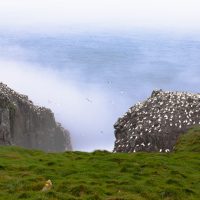
The Southern Avalon region, a mecca for marine biodiversity, is home to a variety of significant habitats, including key sites for sea ducks and important bird areas. Among its many natural treasures is the Cape St. Mary’s Ecological Reserve, noted for its contributions to the area’s overall ecological integrity. Here, the intricate interplay between the cold Labrador Current and the warm Gulf Stream within this area fosters a unique habitat, nurturing a diverse array of species. This region’s emphasis on conservation supports a delicate balance, ensuring that the spectacular array of marine and avian life continues to flourish.
Mistaken Point fossil reserve is also included within the Southern Avalon study area. Among its mudstones are fossils of some of the oldest and largest creatures on Earth. Including Mistaken Point within our study area will allow us to protect the wilderness around this Natural Heritage Site for locals and tourists to learn and explore the historic and present natural beauty of the land.

Eastern Avalon
Newfoundland and Labrador
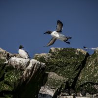
The Eastern Avalon is a bastion of natural splendor, where the rugged coastline and the pristine waters of the North Atlantic converge. It is here that Witless Bay reveals its charm, offering sanctuary to an astonishing diversity of marine species. This area is celebrated for its Witless Bay Ecological Reserve, a haven for the largest puffin colony in North America and a critical feeding ground for humpback whales.
The commitment to preserving the ecological richness of the region is evident in its thriving ecosystems, which continue to enchant visitors and support local communities.
Community Engagement and Workshops
Community engagement sessions are planned throughout the study area, as we aim to encourage community involvement throughout the entire planning process!
If you would like to learn more, request a session, or are interested in being involved in future workshops or community engagement sessions, please fill out the form below.

